This year is the 100th anniversary of the establishment of the Lincoln Highway, the first transcontinental automobile highway in the U.S. It was formally dedicated October 31, 1913 and honored the upcoming 50th anniversary of Lincoln's death. Conceived the year before by entrepreneur Carl G. Fisher (who also conceived the Dixie Highway), the Lincoln began at Times Square and extended to Lincoln Park in San Francisco. Along the way, it passed through over 700 cities and towns and (originally) thirteen states: New York, New Jersey, Pennsylvania, Ohio, Indiana, Illinois, Iowa, Nebraska, Colorado, Wyoming, Utah, Nevada, and California. Later, a loop was established through northern West Virginia. The original Lincoln was 3389 miles long, but with later improvements and realignments the highway extended 3142 miles.
Interestingly, the Lincoln is the oldest memorial to the president: the Lincoln Memorial in D.C. opened a few years later. All but one of these vintage postcards are from western Pennsylvania in or near Greensburg, where my daughter attended college.
In 1928, an effort was made to keep alive the route and memory of the Lincoln Highway: a series of concrete posts laid along the entire road. Each featured a plaque indicating that the road was dedicated to Lincoln, along with the president’s famous profile. Sadly, few of these posts remain. When we lived in Ohio, I was glad to see a post in East Canton, OH in its original location, although some towns have erected replicas of the posts.
About twenty years ago I discovered Drake Hokanson’s Lincoln Highway: Main Street across America (University of Iowa Press,  1989, 1999). His interesting history of the road is enhanced by black and white photography of road scenes, some of them haunting, like the isolated stretches of abandoned road in Utah and California. Hokanson includes photos of several 1928 posts, including the westernmost post on a street corner in San Francisco. Additional histories and guidebooks have since been published, as well as websites. Just a few of those include: http://www.lincolnhighwayassoc.org, http://lincolnhighway.jameslin.name/ , http://www.lhhc.org/highwayhist.asp, and also http://drivelincolnhighway.com/history.html
 1989, 1999). His interesting history of the road is enhanced by black and white photography of road scenes, some of them haunting, like the isolated stretches of abandoned road in Utah and California. Hokanson includes photos of several 1928 posts, including the westernmost post on a street corner in San Francisco. Additional histories and guidebooks have since been published, as well as websites. Just a few of those include: http://www.lincolnhighwayassoc.org, http://lincolnhighway.jameslin.name/ , http://www.lhhc.org/highwayhist.asp, and also http://drivelincolnhighway.com/history.html
 |
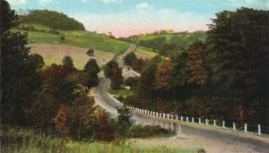
| Notice the red white and blue Lincoln Highway sign on the pole. Today, at the top of that hill in the distance, is a retail area along US 30. |
As you drive two-lane highways, you can occasionally spot earlier alignments, left over when the route was straightened or moved. Around my hometown, Vandalia, IL, I liked to see old alignments of U.S. 40, like the several yards of roadbed just east of the river bridge, and a wide curve at the western edge of town en route to Hagerstown, IL. North of Vandalia, just to the east of the modern U.S. 51, there is an abandoned stretch of the former road, with an old concrete bridge that still has the metal plaque, common on such bridges, which dates the road to the 1910s. I could list several other examples of locations that I like.
I’ve noticed the same thing as I’ve driven the old Lincoln Highway. When we lived in Ohio, one day I drove down State Route 21 down to Massillon and then proceeded east on Lincoln Way (State Route 172), which is the old Lincoln Highway and as well as the original U.S. 30. (U.S. 30 is now routed south of the town.) Driving through Massillon and then Canton on 172, I rejoined highway 30, followed the zigzag road through East Canton, and drove out into the country for a while. I enjoyed seeing the oldest paths of the Lincoln Highway as they moved away from the modern highway, made a long curve, and then reconnected. (http://www.lincolnhighwayoh.com/v1/NearCanton.html)
Whenever I drive U.S. 30 through western Pennsylvania, I spot the same thing: old highway alignments left over when the highway was straightened in the 1940s or thereabouts. Just west of Greensburg, for instance, an alignment curves around to the south and up a hill, then descends the hill and becomes the main street through the town. A mural on a downtown building calls attention to the days when the Lincoln Highway was this street. Then, on the east side of town just past the mall, another original alignment turns to the right and makes a long curve through a neighborhood before rejoining U.S. 30 down the way.
 Many interesting places can be found along the highway, as Hokanson’s and other books show. One was the S.S. Grand View Hotel, a ship-shaped establishment built on the side of a Pennsylvania mountain (http://www.brianbutko.com/lh.ship.html). Kearney, NE, where one of my college friends lives, is the middle-point on the highway between New York and San Francisco.
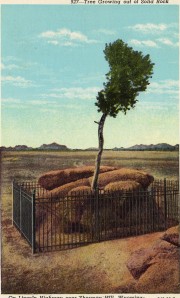
 My grandfather Crawford was the oldest of eight children: three boys and then five girls. Most of the family lived around my hometown but one great-aunt and her husband moved to Laramie, WY. They were named Ruby and Pearl, but since I always knew about them and visited them sometimes, I never stopped to think how funny they were both named for jewels and that Pearl is a different kind of name for a man. They, and their three sons and several grandchildren, were great, hospitable people. During one of our visits to Laramie, when I was about seven, we stopped and saw a famous Lincoln Highway scene, the tree growing from a boulder. I thought that was something fantastic!
That was a long set-up for a small, personal Lincoln Highway memory. But how many millions of small memories–of family visits, vacations, business trips, and so on—define the Lincoln Highway, over its entire coast-to-coast route! But the highway is defined in a different way: not only travelers, but people who lived, worked, and shopped in local business districts through which the road passed.

No comments:
Post a Comment